

All the world’s oceans are connected, forming one huge body of saltwater, the Global Ocean. However, for geographical, historical and cultural factors, we usually divide it into five main ocean basins.
These are the Pacific, Atlantic, Indian, Arctic and Southern ocean basins. All together, they cover about 71% of the Earth’s surface and contain about 97% of all the water on the planet.
The ocean is therefore one of the most important features of our planet: it functions as a life-support system for all living beings, produces more than half of the oxygen we breathe and regulates global climate.
In this article, we will look at the Atlantic Ocean basin and find out all the information we need to understand the role it plays on Earth, including its surface area, volume, depth and much more.
We will not only talk about its geographical details, but also about its ecosystems and biodiversity and what we can do to protect it from the threats it is currently facing.
Keep reading if you want to learn all you need to know about the Atlantic Ocean basin!
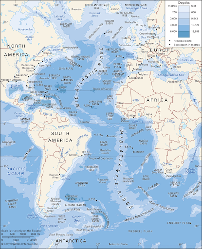
Image: Encyclopædia Britannica, Inc.
How large is the Atlantic Ocean basin?
The Atlantic Ocean basin covers about one-fifth of Earth’s surface, coming right after the Pacific Ocean basin in terms of size, and separates the continents of Europe and Africa from those of South and North America.
The Atlantic has an elongated “S” shape, long and narrow, usually divided at the Equator into North and South Atlantic. The Atlantic is connected to the Pacific through the Arctic Ocean in the North, and the Drake Passage in the South. Another link, man-made, is provided by the Panama Canal.
With its neighbouring seas, it occupies an area of about 106,400,000 square km (41,100,000 sq mi), roughly 20% of the planet’s surface, and without these seas, is approximately 81,760,000 square km (31,568,000 sq mi).
Its name comes from Greek mythology: it is “the sea of Atlas”.
How deep is the Atlantic Ocean basin?
The average depth of the Atlantic is 3,338 metres (10,932 ft) when taking into consideration its dependent seas; without them, it is slightly deeper at 3,926 metres (12,881 ft). The deepest spot is found in the Puerto Rico Trench at 8,605 metres (28,232 ft).
Its width varies considerably from north to South: about 4,830 kilometres (3,000 mi) between North America and northern Africa to 2,848 kilometres (1,770 mi) between Brazil and Liberia.
Climate
The climate of the Atlantic Ocean basin and the bordering land is hugely influenced by the temperatures of the surface waters and water currents, as well as the winds. The North and South Atlantic have different ocean currents that influence their climate and global weather.
Due to the ocean’s capacity for retaining heat, maritime climates are usually moderate and free of extreme seasonal variations.
In the Atlantic, climatic areas vary with latitude: the warmest stretch across the Atlantic north of the equator, while the coldest are in the high latitudes, corresponding to the areas covered by sea ice.
When cold air mixes with warm water, it causes fog, which can sometimes pose problems for sea transportation. For example, the cold water currents contribute to heavy fog near northeastern Canada (the Grand Banks area) and the northwestern coast of Africa.
The Gulf Stream is also a huge influence for the Atlantic climate, warming the atmosphere of the British Isles and northwestern Europe.
When air with large temperature contrasts (polar outbreaks and mild air from the Pacific or tropical areas) meet in what we call fronts, extratropical cyclones are formed, developing into strong vortices and hurricanes, carrying heat and moisture northwards.

Salinity
The surface waters of the North Atlantic reach salinity values that exceed 37 parts per thousand, which are some of the highest found in any ocean.
In the South Atlantic, the salinity values are lower, around 34.5 per thousand. Salinity distribution is usually influenced by precipitation levels and evaporation, and is also related to water currents. This difference, for instance, can be explained by the intense evaporation that takes place in the Mediterranean Sea, and the outflow from it of high-salinity water, which helps maintain the salinity of the North Atlantic higher.
Salinity also depends on the runoff from rivers. The Mediterranean Sea, as we mentioned, has high salinity because the runoff is small and evaporation is great; in the Black Sea and in the Baltic, where large rivers empty, the salinity is low.
Temperature
The distribution of ocean’s surface temperature is closely related to its currents. The waters of the North Equatorial Current move North, and those of the South Equatorial Current move both north and south when reaching the lands of North and South America.
In the tropics, however, surface temperature of the water is influenced by climatological factors, which make it nearly uniform; differences linked to the effects of currents do not appear.
At a depth of about 200 metres in latitude 6° to 7° N temperatures are around 10 °C (50 °F), whereas they rise to 20 °C (68 °F) in latitude 20° N.
In the North Atlantic, the temperature lowers slowly toward the bottom from about 5 °C (41 °F) at 900 metres (3,000 feet) to about 2.5 °C (36.5 °F) at the bottom of the ocean.
Because of climate change, the Atlantic has exhibited increases in temperature anomalies of about 0.05 °C ( 0.1 °F) on the top 9,800 feet (3,000 metres). The fastest rate of warming shown by these anomalies is found in the North Atlantic, at roughly 1 °C (1.8 °F) per century.
Physiographic Regions
The northern and southern boundaries of the Atlantic Ocean basin are often unclear, as there are no universally accepted conventions.
In the North, the matter is complicated by the fact that the Arctic Ocean basin is often considered to be a dependent sea of the Atlantic, and usually the boundaries rely on arbitrary latitude coordinates or linear transects.
Possibly, one appropriate method for defining this boundary is to follow the difference between the distinctive Arctic and Atlantic water masses: the Norwegian Sea has relatively warm and saline waters, which would be part of the Atlantic, while the Greenland Sea would fall into the Arctic with its cold, lower-salinity waters.
There is less ambiguity concerning the southern boundaries of the Atlantic, which is connected to the Southern Ocean basin, which is made up by the waters south of 60° S latitude that surround Antarctica.
In the South-East, the accepted limit between the Atlantic and Indian oceans is a line that starts from Cape Agulhas, at the southern tip of Africa, and follows the 20° E meridian until the 60° S parallel.
On the opposite side, the boundary between the Atlantic and Pacific goes through the Drake Passage, between Cape Horn at the tip of South America and the tip of the Antarctic Peninsula.
Biodiversity
The Atlantic Ocean basin is home to a huge diversity of animal and plant life. Plankton is the basic life form in these regions, and provides food for fish and other wildlife. In the Caribbean Sea and other warmer areas, corals thrive.
Due to its calmer waters and abundant life, more than half of the planet’s fishing grounds are found in the Atlantic Ocean. Here, human beings extract fish and seafood from the ocean for food consumption: mainely lobster, haddock, cod, mackerel, herring, ocean quahogs, menhaden, sea scallops, shrimp, clams, and blue mussels.
Geology
Nowadays, the origins and development of the Atlantic Ocean basin are explained by the theories of continental drift and plate tectonics.
These explain that a vast protocontinent, known as Pangea, began to break up about 180 million years ago. This caused the landmasses of the Western and Eastern hemispheres to separate, thus opening the Atlantic Ocean basin.
The most conclusive evidence supporting this theory is possibly found in the existence of the Mid-Atlantic Ridge, an outstanding feature of the floor of the Atlantic Ocean basin. The ridge is in effect an immense mountain range that extends throughout the length of the Atlantic, reaching roughly 1,600 km (1,000 mi) in breadth. It is formed by underwater mountains, volcanoes, and faulted plateaus and in some places, it reaches above sea level to form islands.

Mineral resources
In the Atlantic, the ocean’s floor is mainly covered with calcareous ooze. At great depths, (over 5,000 metres), the calcium carbonate decreases, and the calcareous deposits give way to red clay. Some of these zones are often carpeted with metallic nodules, formed over millions of years and primarily composed of manganese and iron, and sometimes also copper, nickel, and cobalt.
Underneath all this, under the continental shelves and slopes, lies an incredible wealth of petroleum and natural gases. The amount of recoverable fuel is enormous: some estimates state that one-third of the global recoverable oil and natural gas are found here.
In the northern part of the Atlantic there are also massive coal deposits, but limitations in technology have slowed their exploitation.
The underwater exploration of hydrocarbons, however, has been posing a threat for the ocean environment.
Another important potential energy resource found in the Atlantic Ocean are methane hydrates, which are formed by a gas (methane) surrounded by water molecules in a solid form. At depths greater than 500 metres (1,650 feet), methane hydrates can occur as stable deposits on the ocean floor and can be up to hundreds of feet thick.
Threats
Pollution is one of the major issues that the Global Ocean faces right now, and the Atlantic is no exception.
Pollution is caused mainly by littering, maritime transportation (90% of global trade currently uses sea routes), mining and drilling, oil spills and ocean dumping (the direct discharge of pollutants in the ocean from industries, ships or sewage plants).
To solve this, we must implement better regulations on a regional, national and international level, and make sure everyone complies. Individual action is also greatly important, as we can all reduce our use of plastics and improve the way we dispose of trash.
Other serious threats to the health and balance of the Atlantic are overfishing and illegal fishing practices, which are incredibly destructive for the ocean’s ecosystem.
Overfishing has been threatening many species in the ocean for years, and some of them are in danger of becoming extinct.
Also, fishing practices leave a massive amount of harmful debris, which destroys habitats and marine ecosystems.
Fishing nets, which are usually made of plastic, are often lost in the water, and they make up about 20% of the ocean’s plastic pollution.
References
https://www.britannica.com/place/Atlantic-Ocean
https://www.cs.mcgill.ca/~rwest/wikispeedia/wpcd/wp/a/Atlantic_Ocean.htm
https://www.nationalgeographic.com/environment/article/atlantic-ocean
https://oceanservice.noaa.gov/facts/atlantic.html
https://www.english-online.at/geography/atlantic-ocean/geography-of-the-atlantic-ocean.htm


